Blue Mountains Photography Spots: The 25 Best Spots You Must Visit
25 Photography Spots – Blue Mountains, NSW, Australia
This post is all about showing you the best Blue Mountains photography spots that I can 100% recommend.
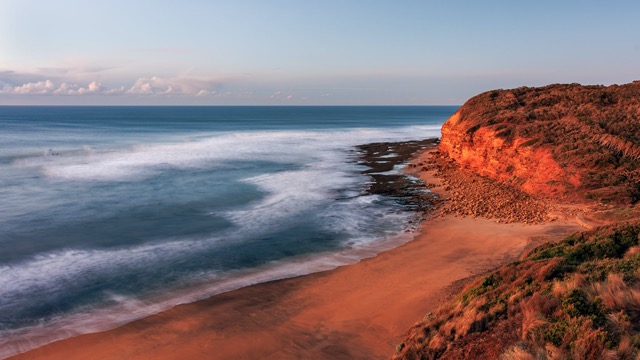
The Blue Mountains is a rugged natural wonderland located less than a two hour drive from Sydney, Australia.
With stunning mountain views, vivid forests, abundant waterfalls, and seemingly endless walking trails, this area is filled with endless photography opportunities.
There are so many photo locations that it can become overwhelming. I have created this list to help you decide and have the perfect photography trip in the Blue Mountains.
These are my top 25 locations highlighting the many photography opportunities showing the incredible diversity available in the Blue Mountains region.
“Always be on the lookout for the presence of wonder”
~ E.B. White (American Author)
Read to the end for a bonus section on other local icons/attractions in the area.
You will always find something exciting to photograph no matter what the weather is like. From weather-protected waterfalls under the canopy of the trees to panoramic vistas of the cliffs from the lookouts listed below.

To make the most of this glorious area, try to spend at least two or three nights in the area. This will allow you some fantastic sunrise and sunset opportunities, along with walks in the forests to explore and discover some of the beautiful waterfalls.
The region also has some lovely villages offering unique shopping and dining experiences. You will have earned some down time after all your exploring and snapping.
Views from the Blue Mountains lookouts are sensational, providing spectacular views of deep valley troughs and rolling peaks.
Their locations range from the end of winding trails, to easy-access short tracks, to lush bushland.
So let’s get started! I will qualify that these are in no particular order as that was way too hard!

Echo Point (Three Sisters)
Located right in the town of Katoomba, the home of The Three Sisters is the absolute star of the Blue Mountains for anyone that visits, this is usually number one on the list – no prize for guessing why!
Seen best from Echo Point the famous Three Sisters are sandstone peaks that rise almost a kilometre above sea level. They were formed thousands of years ago by erosion and overlook Jamison Valley which is dense with eucalyptus trees and are surrounded by incredible sandstone cliffs.
You can also see other incredible rock formations such as Mount Solitary and the Ruined Castle from this vantage point.
Map Location – Right in Katoomba itself. Echo Point lookout (Three Sisters)
Access To Destination – Well maintained paths to various vantage points within five minutes of getting out of your car.
Facilities At Location – Parking (paid after 9am), toilets and the location of the Visitor Centre.
Good To Know – Definitely best to go as early as you can. Parking is free before 9am, and there will be way less people.

Oreades Lookout
Just a few minutes walk from Echo Point is this often neglected viewpoint that offers another stunning view over the incredible vista.

Make sure you continue on for another few minutes to where you can walk over to The Three Sisters crossing the Honeymoon Bridge if you’re brave enough! I have to be honest and say I haven’t been that brave – yet (never say never).
Boars Head
A little tucked away, this is a great lookout overlooking Narrowneck and the Megalong Valley. You may struggle to see why it’s called Boars Head at first, but once you do you won’t unsee it!
The rock formations here are truly amazing, and there’s plenty of space to sit and relax and take in the view! Catching a sunset here is the perfect end to a day – bring a beverage along to sit and enjoy the views if you can.
Map Location – Right in Katoomba itself. Boars Head Lookout
Access To Destination – Short walk from parking your car. There are a few trails but be careful as there are no fences.
Facilities At Location – Parking – limited but this is much less crowded than the Three Sisters so shouldn’t be an issue.
Good To Know – Great sunset location.
Govetts Leap
While the Blue Mountains has no shortage of spectacular lookouts, my absolute favourite is Govetts Leap. I know we shouldn’t have favourites but this really does hold a special place in my heart.
It has such an incredible panoramic view over the Grose Valley, and if you are lucky enough to get some fog, it is simply magical.

Fun fact – It is named after William Govett who was apparently the first European settler to visit here.
Map Location – Just a couple of minutes drive from the centre of Blackheath. Govetts Leap lookout
Access To Destination – Less than a minute’s walk from the car to the top lookout. Wheelchair accessible.
Facilities At Location – Toilets, picnic tables, ample parking.
Good To Know – Fabulous sunrise location. Check out the short walk on the other side of the picnic area to visit George Phillips Lookout
George Phillip’s Lookout
This was a lovely find, and I’m a bit embarrassed that I’d never known about or seen it before. You don’t even have to move your car from Govetts Leap. Seriously just a short walk past another one of those useful huts (and toilets in case you need them), and within 5 minutes you have a view like this –

Map Location – Same parking spot as Govetts Leap. George Phillips Lookout
Access To Destination – Less than a 5 minute easy walk from the car park.
Facilities At Location – Toilets, picnic tables, ample parking.
Good To Know – Visiting in spring could give you the added bonus of native flowers blooming.
Evans Lookout
The Evans Lookout offers breathtaking views of Grose Valley, especially during golden hour when the cliff walls glow orange.
Many of the lookouts have small brick ‘huts’ that come with picnic tables and chairs inside. These can be most useful if you get caught in the inclement weather of the area. They have obviously been very well built. They have withstood the test of time and bushfires that ravaged the area at the end of 2019.

Map Location – About a 15 minute drive from Katoomba. Evans lookout
Access To Destination – Less than a 5 minute walk from the car on an easy path.
Facilities At Location – Toilets, picnic tables and huts, ample parking.
Good To Know – Great sunrise location. Less known so you are pretty much guaranteed the place to yourself, and different to your usual photos.
WENTWORTH FALLS PICNIC AREA
This is the starting point for the next three lookouts –
- Jamison Lookout
- Wentworth Falls
- Princes Rock
This is probably the most famous waterfall in the Blue Mountains, and for good reason. The layered waterfall is 187 metres in height making it the highest and most impressive, particularly after heavy rain.
There are a number of walking tracks in this area ranging from the easy one suggested here to photograph from afar, to others that are definitely more challenging.
Map Location – Not far from the Great Western Highway at Wentworth Falls. Wentworth Falls picnic area
Access – There are numerous ways and vantage points to view Wentworth Falls, but my recommendation for the easiest walk to view the full falls in their entirety is Princes Point Lookout.
Facilities At Location – Picnic area and amenities. Parking can get busy so suggest going earlier in the day, or sunset for stunning photos from Princes Point with Wentworth Falls behind you.
Good To Know – The walk is a little steep but it is well maintained with wide steps.

Jamison Lookout
Unlike other lookouts here, this view does not require a climb to the viewing platform.
This lookout is just off the road and next to the car park, meaning it is perfectly wheelchair accessible.
As lovely as the view is from here, you can’t see much of the actual waterfall from this lookout. Although the views certainly give you an idea of how impressive they are – keep going!

Wentworth Falls Lookout
Just a short walk from Jamison, the Wentworth Falls Lookout also provides views over the Jamison Valley, but from a different angle.
This is the first lookout that gives you better views of the waterfall, but keep going a few more minutes for the full affair.
From the Wentworth Falls lookout point, the main walking track heads down towards the Princes Rock Lookout. It’s this lookout that provides the best views (in my opinion) of the entire waterfall.
Princes Rock Lookout
This lookout offers an incredible view over Jamison Valley – and turn around to finally see the entire Wentworth Falls in all their glory.
In total this walk is less than one kilometre from the picnic area. While it is pretty much downhill to get here, and of course uphill on the way back, it is a very well maintained path and shouldn’t take more than 15 minutes to get back.
TIP – This is a fabulous sunset location

Lincoln’s Rock
At the risk of sounding like a broken record, Lincoln’s Rock really is one of the most impressive lookouts in the Blue Mountains.
Lincoln’s Rock is the perfect place to go to enjoy beautiful Blue Mountain sunsets. It’s easy to access and there’s plenty of space to spread out and enjoy the views.
The beautiful sunset views take in all of the stunning Jamieson Valley with Narrowneck and Three Sisters in the distance. Wentworth Falls gully on the right and Mount Solitary and beyond on the left.

Map Location – Around a 15 minutes drive from the Wentworth Falls Picnic area, there is a carpark that was finished in 2021. Lincoln’s Rock
Access To Destination – An easy 300m walk from the car park
Facilities At Location – Parking only
Good To Know – Great spot with plenty of room to enjoy a picnic.
Victoria Falls
This is accessed via a stretch of dirt road off the Great Western Highway. Although it is unsealed for about five kilometres, it is well maintained.
Just make sure you don’t miss the turnoff as it’s not very well signposted.
Once you get to the carpark at the top of the road, the lookout is only a short walk.
The views over the Grose Valley are considered to be one of the most scenic in the area, so it’s well worth the drive.
You can’t actually see the waterfall from the lookout. To access that you need to do the tougher walk down into the valley.

Map Location – Just off the Great Western Highway, head to the top of the hill and follow the signs to the track. Victoria Falls Rd Victoria Falls walking track
Access To Destination – Less than a five minute walk from the car to the lookout. The walk down to the actual waterfalls is quite a steep walk, and one I’ve not done.
Facilities At Location – Limited parking but this shouldn’t be an issue as it’s not a hugely popular spot. Toilets and picnic tables available.
Good To Know – Perfect to practise panoramic shots with your camera.
Mitchell Ridge
This lookout really was a surprise. I stumbled across it on another blog and had to check it out.
It’s conveniently located right on the side of the Great Western highway, but miraculously you don’t hear any of the traffic once you park less than a couple of hundred metres away.
Not one you will find in most guides, it is nonetheless one that is super easy once again to access and has some lovely spots to sit and enjoy some amazing views over the Kanimbla Valley.

Courtesy of the Visit NSW Website – “Mitchells Ridge Lookout is a historic lookout and rest area, named after Sir Thomas Livingston Mitchell who supervised the building of the Pass by convict labour in 1832. An obelisk at the lookout commemorates the opening of Victoria Pass in 1832. The Pass is one of the oldest and most significant engineered works in Australia still in use today.”
After this one it was time to head back to Katoomba (a whole 20 minutes away). Plenty of time for a nanna nap before going out again for sunset.
Map Location – Mitchell Ridge Lookout
Access To Destination – short flat walk to various unobstructed views.
Facilities At Location – Plenty of parking, picnic tables and huts.
Good To Know – this would be great to break up your day with a picnic lunch up here.
Mount Blackheath
This is a perfect end to a day photographing in the Blue Mountains. It is a bit of a drive but still only about thirty minutes from Katoomba.
It is very quiet as it is a bit of a hidden gem where there aren’t many people. Both times I’ve been there at sunset there has only been one other car in the area – winning!
It does have a grass area where the paragliders take off from, but you’re pretty much guaranteed not to see any of these at sunset – so peaceful.
Mount Blackheath and wine What a view – Don’t be fooled by the versatile mug – it’s sunset so that’s holding a nice cabernet

Map Location – Mount Blackheath
Access To Destination – Walk from parking is only a couple of minutes – just be careful as it’s not a great path.
Facilities At Location – Plenty of parking, picnic tables.
Good To Know – Great sunset location.
Katoomba Cascades
Right in the centre of the town of Katoomba, there’s no excuse to miss this little gem. A lovely oasis right and perfect for a break in the middle of your exploring day.
The Katoomba Cascades area has a dedicated car park along Cliff Drive at the large grassy area with picnic tables. Be aware though, as it is so easily accessible it can get very busy!
These are best visited after heavy rains to see them at their best, and particularly beautiful with. There are also plenty of places to sit and admire the views.
From here you can access a few nearby walking tracks including the night lit walk.
Map Location – Right in the centre of Katoomba Katoomba Falls
Access To Waterfall – A short walk from the car down with about 100 stairs but can be seen from the top if you are unable to manage stairs.
Facilities At Location – Picnic area and toilets nearby, ample parking.
Good To Know – You can really get up close and personal with these falls. Best to photograph in the afternoon after the sun has dipped behind the trees to avoid harsh sun glare earlier.

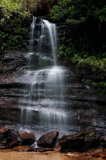
Leura Cascades
A beautiful short walk along a boardwalk. This takes you along the creek through the forest and within a few short minutes you are up close and personal with Leura Cascades, a lovely series of small but still beautiful waterfalls.
There are a number of viewpoints to take photos from so be sure to explore.
Be sure to continue a few minutes further on to a stunning lookout with stunning views across the valley. There are more difficult walks you can continue on from there if you wish to research that.
Map Location – Leura Cascades Picnic Area
Access To Waterfall – Easy 10 minute walk from the picnic area
Facilities At Location – Toilets, picnic tables, ample parking.
Good To Know – Check for the nearest parking area and access as there was a serious landslide here in 2020 and not all tracks were open at time of writing.

SOUTH LAWSON WATERFALL CIRCUIT
There are five waterfalls along this lovely walk –
- Adelina
- Junction
- Leslie
- Federal
- Cataract
This is kind of a secret location as in it’s way less well known, and therefore popular, than those mentioned so far.
The full walk is around 2.5km and is classed as ‘easy’. This must be a fit ‘hiker’ grading. I would say it’s leaning towards moderate, but is well maintained with steps and no real danger areas from what I experienced.
It really is admirable the amount of work done to keep all of these walks and stairs maintained considering the vastness of the area and the damage it has experienced over the years.
While these falls aren’t as big or ‘magestic’ as some of the other waterfalls mentioned, these are well worth visiting for very different picturesque waterfalls.
Map Location – South Lawson Waterfall Circular Walking Track
Access To Waterfall – The path is well signed as you go around this loop. Depending on how long you take to photograph each fall, the whole circuit should take less than 2 hours.
Facilities At Location – Parking only. Head back to Lawson for facilities.
Good To Know – Best to go after good rains to avoid disappointment – as mentioned earlier they are not large falls, but they are definitely worth a visit and stroll.
Adeline and Federal Falls
Terrace Falls and Solote Pool
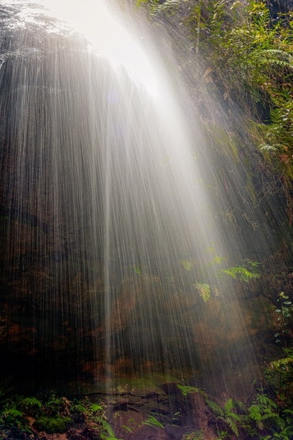
This is a walk that definitely requires allocating a couple of hours to explore Terrace Falls, Solote Pool and the beautiful brooks and forest throughout.
It is one of the lesser known areas and definitely best after decent rainfall.

Story behind the Solote Pool photo – ‘The Key To Peace’. Travelling back to Solote Pool in the Blue Mountains 2020.
We were just about to leave this gorgeous little spot when I saw something on the ground next to my friend. It turns out it was the keys to our accommodation for the week. Needless to say I became the keeper of the key for the rest of our trip and hence the name of this photo 😂
Up until now this post has only listed waterfalls that don’t really require any self-navigation skills. From here on in though I’d recommend a guide unless you’re an experienced and confident hiker who has done their research and has appropriate safety equipment.
If not, get yourself an experienced local or guide that has been here previously.
It is definitely a beautiful walk through the forest with numerous ferns and unique little brooks like I’ve not seen anywhere else.

Map Location – Terrace Falls
Access To Waterfall – A decent walk graded ‘medium’. Numerous high steps that can be slippery.
Facilities At Location – Parking only. Head back to Lawson for facilities.
Good To Know – Best to photograph earlier in the day before the sun pops up over the top above Terrace Falls.
VALLEY OF THE WATERS
There are three waterfalls along this walk –
- Empress Falls
- Sylvia Falls
- Lodore Falls
This is the most challenging walk listed here, but oh so worth it. Although only 1.5km return in distance it is ALL stairs.
A wise person once said that ‘whatever goes down must come up’ – ok, maybe not so wise, but it has never been truer than on this walk.
There are numerous points to stop along the way to enjoy the views of the Jamison Valley and beyond – and to catch your breath on the way back up.

The first falls you will come to is Empress Falls. You can photograph these from behind a barrier with stepping stones, and from either side. Because of this you get unobstructed views for even better photos.
It is a popular location for abseilers to arrive at, so you could also get lucky enough to witness this.
Next up, less than 5 minutes further (don’t give up) is the magical Sylvia Falls. These are one of the most popular with photographers and it’s easy to see why. The cascades falling down the black rock formations dotted with ferns makes for stunning photos.
Fun Fact – locals and photographers are able to tell if you visited Sylvia Falls before or after early 2020 due to the addition of a certain log that came down during a particularly rough storm (this log is in full view of my photo). Some now call it ‘Simon’ Falls and I’ll leave it to you to figure out why lol.

Just a few more steps after this is Lodore Falls. The walk does continue on for a much longer walk but this post ends here where you turn around and retrace your steps back to the Conservation Hut where you started.
Lodore Falls was my absolute favourite of the 3, however the day I was there a huge thunderstorm started and we had to leave due to safety reasons. As much as I would have liked to have more time here I do value safety more so took heed of the guide i was with that day.
Don’t forget the little things when you’re visiting these areas – I particularly liked finding smaller intimate scenes like this one, even if it did mean getting my feet wet every now and then.

Map Location – Valley of the Waters picnic area
Access To Waterfall – Allow at least 2 hours return – this accounts for enough time to photograph the 3 waterfalls and breathing breaks to get back out. Lots and lots (did I mention lots) of stairs down and then of course back up. Includes some sections of steel staircases mixed with rock and less secure parts, so decent shoes, and possibly a walking pole (tripod comes in handy for this).
Facilities At Location – Toilets, and ample parking. Lovely cafe to be rewarded with at the end.
Good To Know – that’s the last of the waterfalls, and uphill climbs in this post lol.
WHEN TO VISIT THE BLUE MOUNTAINS
Although the Blue Mountains can be visited at any time of year, be aware that, due to the nature of the terrain, the weather can vary greatly throughout the year.
Please be aware that as our weather patterns are changing dramatically, so this is just a rough guide.
Spring (September – November)
This is arguably the best season for photographers due to increased chance of mist through the valleys and great cloud formations.
Waterfalls are also usually at their best flow after the winter rains.
It also occasionally snows in the highest parts of the region.
Spring can also be the best time for native flowers, particularly Australia’s beautiful Flannel Flowers.
Summer (December – February)
These are typically the driest months of the year, so don’t expect waterfalls to be at their peak.
While it is obviously hotter in summer, the days are also longer. This is perfect for those early starts if heading out for longer hikes. Once you’re deep down the trails it can be cooler, and you can get back out before that midday sun starts beating.
The rain does increase towards the end of summer to make waterfalls start flowing better.
Autumn (March – May)
Although not known particularly for autumn foliage, there are pockets like Mount Wilson, that are well worth visiting.
There are also streets in Blackheath worth visiting, along with the Botanic Gardens at Mount Tomah.
Autumn is a great time to visit for more consistent weather, making it great for those longer hikes.

Winter (June – August)
While not known for great snowfall, it does happen on occasion, most often around Oberon, and not usually for more than a day or two.
This can be the wettest season which makes it a great time to photograph the many waterfalls in the area. But, keep an eye out if there has been TOO much rain. This can cause closures and make it too dangerous to visit.
OTHER LOCAL ATTRACTIONS
This post has focused mostly on lookouts and waterfalls, and it really does only touch the surface. You could easily spend weeks here and still leave wanting more.
This guide was written for the more common stay of only a few days. If you’re keen, you could easily get to all of the above in three to four days.
If you haven’t had enough exploring yet, or you’ve still got time, the following are more than worth researching –
- Mount Wilson
- Botanic Gardens
- Scenic World
- Blast Furnace Lithgow
- Jenolan Caves
Safety note – if you’re not a confident hiker with appropriate safety training equipment (including safety tracking devices) a local registered guide is highly recommended.
Even though the Blue Mountains is less than 2 hours from Sydney, so much of the area doesn’t have mobile reception due to the ruggedness of the area so extreme care and precautions need to be taken. There are numerous rescues undertaken weekly here by inexperienced walkers and adventurers – please don’t be one of those.
There truly are countless photography opportunities in the Blue Mountains that they couldn’t possibly be fit into one guide.
I do hope this has given you some inspiration to get out there and explore. Don’t be afraid to discover more if you have time!
One thing is for sure – no matter how long or short your visit is, you won’t be disappointed.
If it wasn’t for the cold winters I think I could live in the Blue Mountains. Seeing as I don’t, visiting two or three times a year will have to suffice.
I truly hope you’ve enjoyed this post.
Have you been to this amazing area? What is your favourite spot here, or what’s on the top of your list to visit? Let me know in the comments below.
That’s it for now – Keep clicking and stay caffeinated
Like this post? PIN it so you can save it for later

Here’s some more articles and resources I think you’ll like:
- Central Coast sunrise locations (also near Sydney)
- Guide to photographing waterfalls
- Using a circular polarising filter (great for waterfalls and forests)
- Travel photography tips
- Essential landscape photography gear
- Photography in the rain (often the best time to photograph waterfalls & forests)
- Tasmania Photo Locations: 25 Must-Go Spots For Great Photos
Don’t miss a post – sign up Here if you haven’t already
Note – This post does not contain any sponsored or affiliated links. All suggestions and opinions are mine. Unless otherwise stated, all photos are mine and remain my copyright images – Sam Wilson Photography.